GES Modules
GES 2D Mapping
2D Volumetrics
Based on geological analysis, users can perform reservoir calculator in 2D volumetrics module. There are 4 steps in GES, general settings, fluid contact, property settings and output. GES provide two different levels to meet the needs of different geological exploration stage, two different boundary settings to meet your project needs. And for parameters, users can use maps or constant value.
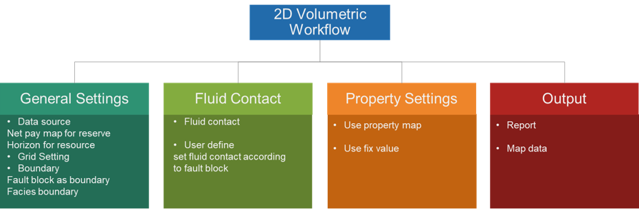
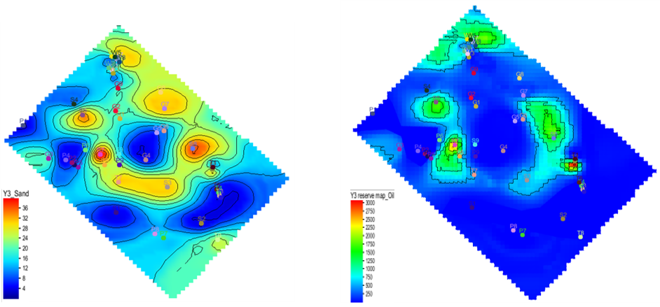
Fig. Sand map (left) and oil reservoir map (right)
Steps to perform 2D Volumetrics in GES:
· Go to Geological Evaluation scenario/Geology & Modeling Scenario → 2D Volumetrics → Reserve Calculator
· General Settings: Check Reserve Calculation, select a map for Sand Map or Check Resource Calculation, select maps for Top Surface and Bottom Surface → Set Grid increment → Choose closed line for Boundary → Choose maps for fault blocks or facies zones if needed
· Fluid Contact: Choose Polygons of gas/oil or user-defined
· Parameters Settings: → Choose Items → Set values for each parameters of every items
· Output: Set output file or surface
Production Curve
GES offers Production Curve tool to allow production data visualization for individual wells.
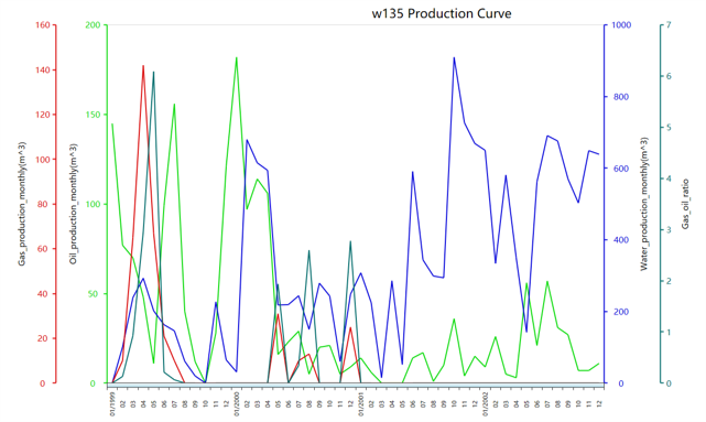
Fig. Production curve of well w135
Steps to perform Production Curve in GES:
· Go to Geological Evaluation scenario/Geology & Modeling Scenario → Geology Evaluation → Production Curve
· Select data for Data Type → Select a well for Well Name → Check the data you want to display in Data Fields → Set Date Range → Input Title → Click OK
Production Map
Production map utilizes bubble map or bar chart to display production data on a map. It is usually shown with property maps such as net pay map and isochore map to provide an independent verification of any geological evaluation. GES provide two different production maps, bubble map and bar chart.
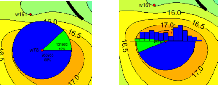
Fig. Production curve of well w135
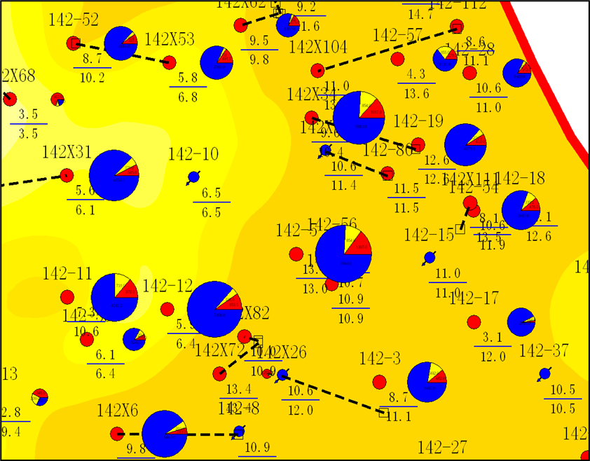
Fig. Bubble map overlay with sand map
Steps to perform Production Map in GES:
· Go to Geological Evaluation scenario/Geology & Modeling Scenario → Geology Evaluation → Production Map
· Input Map name → Check Bubble Map or Bar Chart → Select data for Data Fields → Select Well → Set Start Date and End Date → Click OK
Property Map
In GES, when perform reservoir map, you can set the boundary to constrain property distribution, property map can also be constrained by facies map.
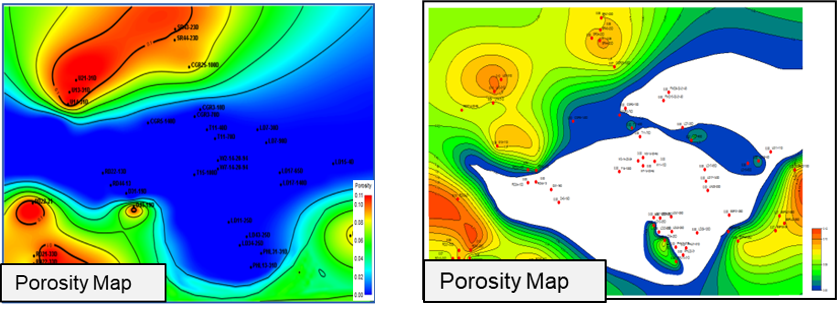
Fig. Porosity map without boundary constrain(left) and using boundary constrain(right)
Steps to perform Property Map in GES:
· Get porosity average result for zone from logs: Go to Data Pane → Click Stratigraphy→ Right Click → Click Property Calculator → Input Property Name → Select Continuous for Type → Select Stratigraphy Scheme → Choose To Zone → Select log for Log Name → Select Algorithm → Click OK
· Go to Geological Evaluation scenario/Geology & Modeling Scenario → Geology Evaluation → Porosity Map
· Select the zone → Select facies result calculated in step 1 → Click Automatic → Set Connection Radium and Source Direction → Choose Boundary → Input facies layer → Click OK
Grain Size Analysis
Grain size analysis is used to understand sedimentary facies, provenance, and source. GES uses grain size data to analyze phi value, sorting, skewness and kurtosis.
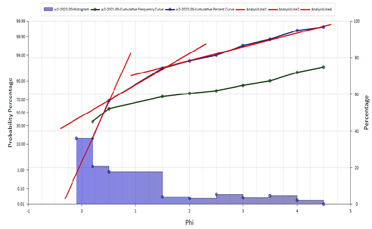
Fig. Probability percentage histogram
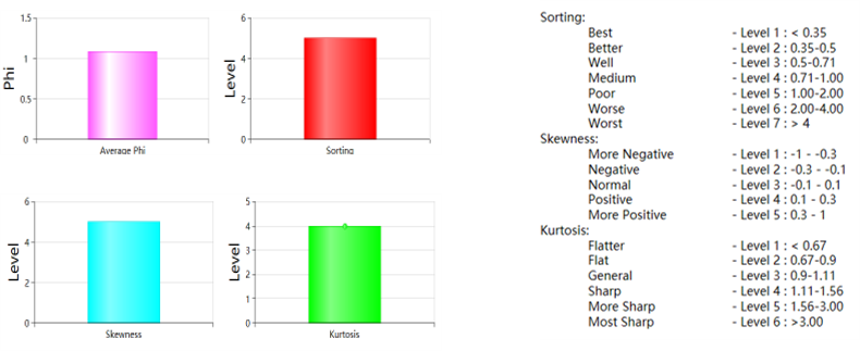
Fig. Average value histogram and legend
Steps to perform Grain Size Analysis in GES:
· Go to Geological Evaluation scenario/Geology & Modeling Scenario → Geology Evaluation → Grain Size Analysis
· Select a well → Input Diagram Name → Set Depth → Click OK
Mineral Analysis
By compositional analysis of feldspar, quartz and rock debris, rock type can be determined. GES provides sedimentary rock common triangular template for feldspar, quartz and rock debris. After importing mineral data, triangular map can be generated in Mineral analysis module.
In addition, the 3-terminal element of the template can be edited as well, and you can define your own template according to different situations.
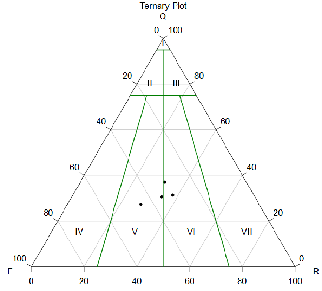
Fig. Probability percentage histogram
Steps to perform Mineral Analysis in GES:
· Go to Geological Evaluation scenario/Geology & Modeling Scenario → Geology Evaluation → Mineral Analysis
· Select a well → Click OK