Graduate student completing thesis using GES
Graduate student completing thesis using GES
Master candidate Hadjara Boubacar S Zataou from Nigeria has completed her final thesis using GES software while studying in China University of Geosciences.
If you are a student that needs a mapping and modeling software to complete your educational studies, please contact us and we will provide a free software to support your studies.
Thesis tile: Three-dimensional Reservoir Geological Modeling of Chang 2 Reservoir in Upper Triassic Yanchang Formation in Zhangtianqu Oilfield, Ordos Basin
Abstract:
The quantitative characterization of reservoir is to better describe the characteristics of reservoir, in which the most important characterization parameters include physical characteristics, production dynamic prediction and reservoir simulation, which require multidisciplinary cooperation to complete. Taking Yanchang Formation and Yan’an Formation of Upper Jurassic Zhangtianqu Oilfield in Ordos Basin, China as examples, three-dimensional reservoir geological modeling is carried out. The sedimentary facies, petrophysical characteristics, geological modeling and reserve estimation of the second layer of Yanchang formation are emphasized.
The Upper Triassic Yanchang Formation is one of the main reservoirs in Zhangtianqu Oilfield, which is classified as a tight sandstone reservoir. In this paper, logging analysis of 38 wells in different areas of the oil field is carried out to obtain formation, sedimentary characteristics and main petrophysical characteristics. Two common density-neutron porosity log values are lacking in the estimation of muddy content by single-mud index and dual-mud index. Therefore, the lithology is identified by the alpha method based on natural potential SP and the muddy content method based on natural gamma GR. Water saturation was calculated using the Archie formula. all the calculated results were compared with the measured core data and the original geological report to determine the accuracy of the calculated results. A combined of porosity, Irreducible water saturation and formation resistivity factor (R) method was applied to calculate and correct the permeability and predict the un-cored wells permeability as well.
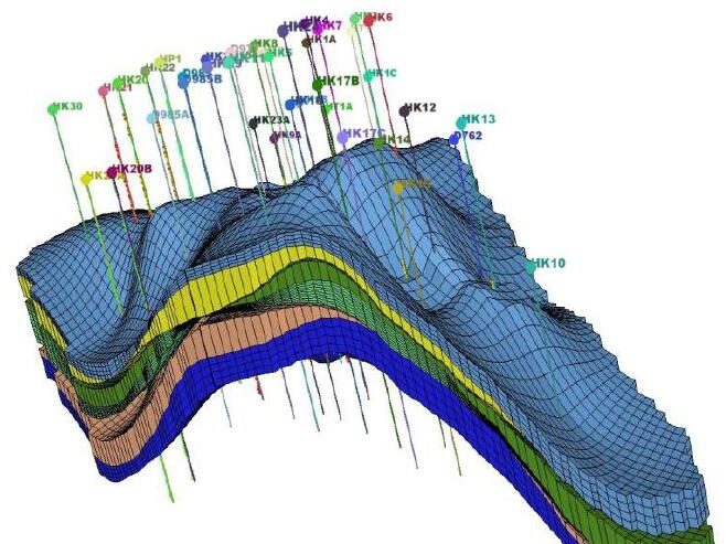
The Geological Evaluation Software GES provided by GPT Software was used to establish an accurate static geological model based on the heterogeneity of rock phase and physical properties. The model should be robust enough to effectively guide reservoir management. This was achieved through an improved understanding of the various rock phases, their distribution and relationship with the petrophysical properties (porosity, permeabilityand water saturation).
From the collected core description data, based on the vertical distribution of rock phase, Lithofacies probability maps and models were established then used to constraint the petrophysical properties models. The lithofacies model is established by using the geostatistical Sequence Indicator simulation method and rock phase control. The physical properties of rock were modeled by stratification and constrained by the rock phase model through the use of Sequential Gaussian simulation method. Tying the petrophysical property distribution to the lithofacies ensured a static geological model that was consistent with the geologic understanding of the reservoir. Lastly, the reservoir geological reserves were estimated by volumetric method.
As a result, the main reservoir CH2 small-layer sedimentary facies are fine sandstone and siltstone reservoirs in the river-lake delta environment, interbedded with non-permeable mudstone layers, representing a barrier to the fluid flow. The sand body porosity of petrophysical model is between 11% and 22.47% respectively. The average permeability is 1.3-130×10-3μm2, the muddy ranges between 1.39-100 and the oil saturation is approximately 0.65.
On the basis of the principle of Petrophysical Cutoff value, out of Six reservoir units, CH211, CH212 and CH221 are believed to contain most of the oil reserves and are considered to be the pay reservoir units and the results can provide geological basis for further development and adjustment CH2 reservoir.
Keywords: Chang2 Reservoir in Zhangtianqu Oilfield; Sedimentary Microfacies; 3D Static Modeling; GES Software; Reserve Estimation.


Message